Use of GIS and RS Technology in Disaster Management
Use of remote sensing and GIS in disaster management
India is vulnerable to natural and manmade disasters. All disasters are spatial in nature. GIS techniques act as a decision support tool. Decision-making can possible by the analysis of different GIS layers. Currently, socio-economic and geo-spatial data is useful for the management and planning of disasters as well as tackling disastrous conditions. Various departments and agencies are stakeholders using GIS in the disaster management process. GIS, RS & GPS is useful in disaster management applications & for decision making. The evolution of computer technology and the availability of hardware is helpful for the rapid expansion of GIS in both disaster research and practice.
GIS is useful for hazard zone mapping and during emergency conditions mitigation of people can easily possible using these maps. GIS and RS are much beneficial in mitigation strategies and preparedness plans. Real-time geographic data can improve the allocation of resources for response. GIS technologies are much useful in the modeling of disaster risks and human adaptations to hazards. It also provides a decision support system in disaster management.
Disaster Management System
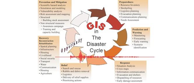
- Mitigation: Emergency is the discipline of dealing with and avoiding risks. It is a discipline that involves, steps taken to contain or reduce the effects of an anticipated or already occurred disastrous event.
- Preparedness: It is how we change behavior to limit the impact of disaster events on people.
- Response: An effective plan for public health and other personnel during a disaster would outline activities designed to minimize the effects of the catastrophe. These efforts can be summarized as closely situation analysis and response.
- Disaster Recovery: The aim of the recovery phase is to restore the affected area to its previous state. Recovery efforts are concerned with issues and decisions that must be made after immediate needs are addressed.
Disaster Management is done by following steps
- Planning and Analysis
- Situational Awareness
- Data Management
- Field Operations
Planning and Analysis
GIS is the most complete information system for modeling, analyzing spatial data, and displaying community vulnerability. When we identify hazard locations with critical infrastructure. Processed GIS Models can be useful for the determination of event impact and necessary mitigation requirements. Preparedness is important when a disastrous event occurs. An analysis of risk and hazards is beneficial in an emergency management program.
Situational Awareness
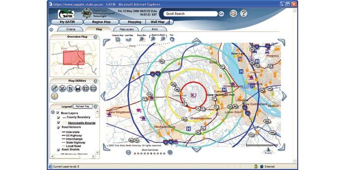
Disaster and emergency management in situational awareness is an essential thing. GIS techniques play a vital role to provide locational information of the event, that is, where does the event happens and what happening exactly in real-time. Also by linking people, processes spatial information situational awareness established. GIS map interfaces important in handling emergency conditions.
Data Management
To the achievement of preparedness, a gathering of information and its advanced data storing is important. In GIS, the integration of information from other sources is possible. GIS solution is standards-based. Accurate cataloging of GIS data provides useful information during emergency conditions.
Field Operations
Field data is very important in GIS applications and Mobile GIS provides crucial information. Field teams capture information and sent it back to the user. So ground information useful for recognizing actual event conditions. Then new data can be sent to operation teams in the field (where the disaster occurs), so they have the information possible for protecting lives and providing safety to people. Whether it’s a response or recovery phase, Mobile GIS provides the right information.
Important objectives of GIS database generation are,
Disaster managers from different state, city, village level using GIS database for disaster planning.
- Preparedness and planning of disasters
- Forecasting and early warning of a disastrous event
- For relief management, rescue operations
GIS database with various themes is helpful to disaster managers in decision making process when catastrophic event occur.
GIS database include following information which is beneficial in disaster management.
- Use of different satellite imageries (Remote Sensing data) ex. Quickbird, SPOT, IKONOS for GIS data creation.
- Preparation of base map of different themes using satellite imageries.
- Thematic maps such as a hydro geomorphologic map, slope map, terrain map, and DEM generation in GIS. It is used for disaster planning.
- Macro and micro-level maps used for identifying vulnerability and threat condition
- Identification of safe locations and zones for rehabilitation
- Road and location maps used for finding alternate routes, shelters, and locations
- Planning of evacuation and operation
- Management of Rehabilitation and post-disaster reconstruction.
- Suitable locations identifying scientifically for construction of houses and shelters
- No construction areas identified and rehabilitation of existing people can be done.
- Hospitals and medical facilities identification for injured people.
GIS solutions for different hazards
1. Earthquake
- GIS can be useful for monitoring historical sites of the earthquake also for Response & data management for recovery.
- It’s also useful for Impact assessment.
2. Flood
- Flood mapping from Macro level to Micro level.
- Flood Zone mapping.
- Detecting Potential Site of Flood in reference with rainfall
- Elevation Mapping
- Preparing Response map in response to managing after flood situations
- Achieving Secure, Reliable Compliance with India’s Data Sovereignty Mandates - November 17, 2025
- Implementing GPU workloads in critical government application - November 12, 2025
- Why the BFSI Industry Needs GPUaaS Now - October 31, 2025