India may get less than 80% Rainfall in this Monsoon
We may get less than 80% Rainfall in this Monsoon
Before you scroll down to read my logical reasoning for using the above subject, it is extremely important to understand in few words about Monsoon.
South-west Monsoon ( Indian Monsoon )
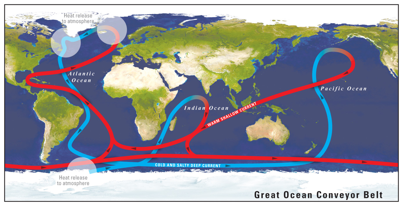
This Monsoon results in rainfall on Indian subcontinent, especially due to hot and humid air created in the Indian Ocean hot water, which can be seen from the Global Conveyor Belt map below
The warm humid air of Indian Ocean heads towards Himalayas and Tibetan plateau from June – September, as the air over this large part of Himalayan range and Tibetan plateau is extremely dry and relatively warm during the latter part of summer.
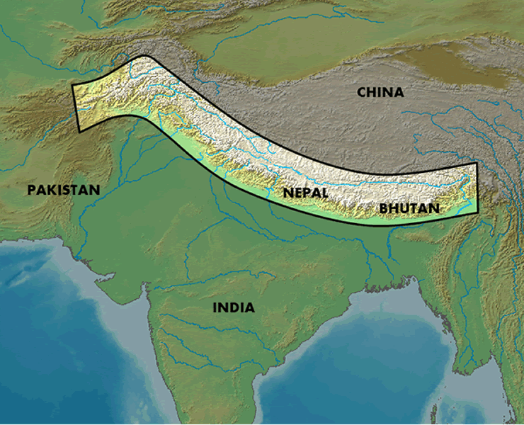
The highlighted portion in the above image is the main source of Monsoon rainfall in India. This region is covered with snow in Winter and significant amount of snow melts by the month of May. As the air becomes dry in this region and comparatively warmer in latter part of summer, so the Monsoon winds start heading for this part, which can be clearly understood from the following image :-

World’s 4 big rivers which provide water for 25% population of world and cover major parts of Asia originate from Himalayas. Region around the holy Mount Kailash collects maximum rainfall during monsoon and feeds 4 big rivers. The Indus River, the Sutlej River , the Brahmaputra River, and the Karnali River (a tributary of the River Ganga) originate from the mount Kailash.
What has gone wrong this year(2014) ?
This entire Himalayan range received heavy snowfall in the month of April and May 2014, which is very rare. Such heavy snowfall in this entire Himalayan range has not allowed the wind to get dry and warm. This major change in Himalayan weather this year has resulted in “No pull” for monsoon winds towards Himalayas. The humid air that was created in the Indian Ocean got pulled towards the African and Middle-east region. The “Nanauk Cyclone” carried our first part of monsoon humidity towards Africa and the extremely dry and hot air of Africa and Middle-east region mixed with the humidity carried by “Nanauk” and it has only helped the region to get some relief from the hot and dry summer, nothing else.
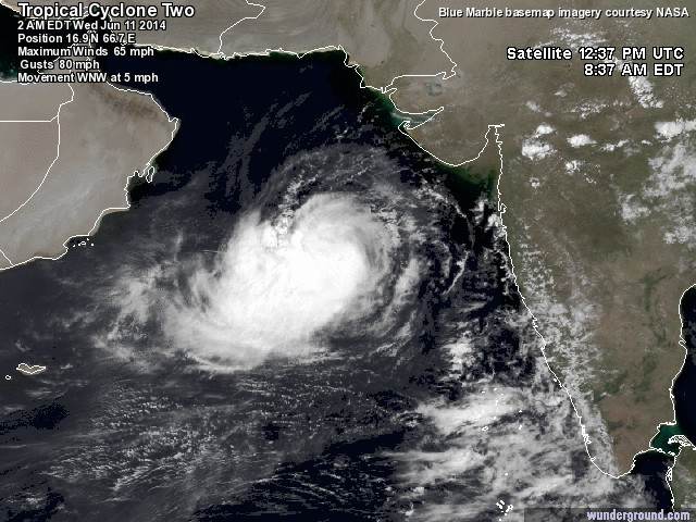
Position of Nanauk Cyclone on 11th June 2014
Why our weather forecast department lacks accuracy?
Our weather forecast department has not invested in technology so far. The weather forecast department of America is the biggest customer of AWS(Amazon Cloud), as they process a lot of data using tens of thousands of CPU’s on the Amazon cloud every morning to make accurate weather forecast. Unfortunately we are still in the process of making a better super computer in India and we don’t want to consider Cloud Hosting as an option to process the amount of satellite and ground level data for weather forecast. Cost of making and running a super computer is far more than what the government would need to invest in Cloud Hosting, there’s no fear of data loss as well if government hosts Weather Forecast data on Cloud, as leakage of the Data cannot help our enemies or anyone else.
Our weather forecast department hasn’t yet noticed that there was no snow left in the Himalayan region near Badrinath – Kedarnath last year before the disastrous floods of Uttarakhand, while at this point of time the mountains are still covered with thick snow in the region.
Another bad news comes from the China side, as a new cyclone named “Typhoon Hagibis” is heading towards Hong Kong, which has pulled humidity from the Indian ocean from the east side.
All hopes are now on the quickly melting snow in the Himalayas. Unless the Air in the Himalayan and Tibetan plateau becomes dry and warm, Monsoon won’t progress beyond the western ghats and the North East(Assam side) region.
Geography and weather forecast has been my favorite subject since childhood. I have previously written a similar article on our eUKhost forum as well, which can be read at :- http://forums.eukhost.com/f17/global-warming-impact-uk-2736/ . Reason to write this article by doing so much research is to spread the message amongst the Farmers and other people of India to save water this year. We will need to preserve Dam water and also see that the storage water capacity increases all over India to avoid trouble similar to what we will be experiencing in next 12-14 months.

- India may get less than 80% Rainfall in this Monsoon - June 14, 2014
Good to see a young business man investing lot of time for welfare and information for
common man.
"We have kept food, water, medicines here at the Langar on the way to Amarnath shrine. There is 20 feet snow at some places, We have never seen such a heavy snow in last 15 years. The lingam formation is good. I think they are going to last till Raksha Bandhan," another volunteer said.
Read more :- http://m.ibnlive.com/news/amarnath-yatra-begins-s…
Monsoon can never progress unless the Himalayan snow melts and significant amount of Monsoon pulling heat gets generated on himalayan plateau and mountains. this logic is very simple and our weather forecast department as well as media should know this upfront. hopefully most of the snow will melt soon, as most of this snow is fresh snow received in April and May 2014.
Rains will come from 10th July as per the weather forecast department in the bottom half of India and North-east, but the heating of northern India and Himalayan range has slowed down. unless the huge surface of Himalayan moutains gets exposed to Sun and heats up, Monsoon won't make much progress. people have not understood the seriousness of the current situation, but real pain will come in mid july if the snow in himalayan range doesn't melt and monsoon won't progress further.